National Register of Historic Places listings in Douglas County, Georgia
This is a list of properties and districts in Douglas County, Georgia that are listed on the National Register of Historic Places (NRHP).
Map all coordinates using OpenStreetMap
Download coordinates as:
- KML
- GPX (all coordinates)
- GPX (primary coordinates)
- GPX (secondary coordinates)
This National Park Service list is complete through NPS recent listings posted September 5, 2024.[1]
- v
- t
- e
Properties on the National Register of Historic Places in Georgia by county
- Appling
- Atkinson
- Bacon
- Baker
- Baldwin
- Banks
- Barrow
- Bartow
- Ben Hill
- Berrien
- Bibb
- Bleckley
- Brantley
- Brooks
- Bryan
- Bulloch
- Burke
- Butts
- Calhoun
- Camden
- Candler
- Carroll
- Catoosa
- Charlton
- Chatham
- Chattahoochee
- Chattooga
- Cherokee
- Clarke
- Clay
- Clayton
- Clinch
- Cobb
- Coffee
- Colquitt
- Columbia
- Cook
- Coweta
- Crawford
- Crisp
- Dade
- Dawson
- Decatur
- DeKalb
- Dodge
- Dooly
- Dougherty
- Douglas
- Early
- Echols
- Effingham
- Elbert
- Emanuel
- Evans
- Fannin
- Fayette
- Floyd
- Forsyth
- Franklin
- Fulton
- Gilmer
- Glascock
- Glynn
- Gordon
- Grady
- Greene
- Gwinnett
- Habersham
- Hall
- Hancock
- Haralson
- Harris
- Hart
- Heard
- Henry
- Houston
- Irwin
- Jackson
- Jasper
- Jeff Davis
- Jefferson
- Jenkins
- Johnson
- Jones
- Lamar
- Lanier
- Laurens
- Lee
- Liberty
- Lincoln
- Long
- Lowndes
- Lumpkin
- Macon
- Madison
- Marion
- McDuffie
- McIntosh
- Meriwether
- Miller
- Mitchell
- Monroe
- Montgomery
- Morgan
- Murray
- Muscogee
- Newton
- Oconee
- Oglethorpe
- Paulding
- Peach
- Pickens
- Pierce
- Pike
- Polk
- Pulaski
- Putnam
- Quitman
- Rabun
- Randolph
- Richmond
- Rockdale
- Schley
- Screven
- Seminole
- Spalding
- Stephens
- Stewart
- Sumter
- Talbot
- Taliaferro
- Tattnall
- Taylor
- Telfair
- Terrell
- Thomas
- Tift
- Toombs
- Towns
- Treutlen
- Troup
- Turner
- Twiggs
- Union
- Upson
- Walker
- Walton
- Ware
- Warren
- Washington
- Wayne
- Webster
- Wheeler
- White
- Whitfield
- Wilcox
- Wilkes
- Wilkinson
- Worth

Current listings
| [2] | Name on the Register | Image | Date listed[3] | Location | City or town | Description |
|---|---|---|---|---|---|---|
| 1 | Basket Creek Cemetery |  | May 20, 2009 (#09000326) | 7829 Capps Ferry Rd. 33°35′24″N 84°49′14″W / 33.590006°N 84.820497°W / 33.590006; -84.820497 (Basket Creek Cemetery) | Douglasville | |
| 2 | Beulah Grove Lodge No. 372, Free and Accepted York Masons-Pleasant Grove School | 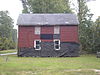 | February 3, 2010 (#09001301) | 2525 Old Lower River Rd. 33°42′24″N 84°39′29″W / 33.706586°N 84.657931°W / 33.706586; -84.657931 (Beulah Grove Lodge No. 372, Free and Accepted York Masons-Pleasant Grove School) | Douglasville | |
| 3 | John Thomas Carnes Family Log House | 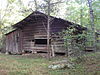 | July 25, 2001 (#01000762) | Clinton Nature Preserve, 8270 Ephesus Church Rd. 33°42′16″N 84°52′32″W / 33.704444°N 84.875556°W / 33.704444; -84.875556 (John Thomas Carnes Family Log House) | Winston | |
| 4 | Douglas County Courthouse |  | October 24, 2002 (#02001216) | 6754 W. Broad St. 33°44′59″N 84°45′01″W / 33.749722°N 84.750278°W / 33.749722; -84.750278 (Douglas County Courthouse) | Douglasville | |
| 5 | Douglasville Commercial Historic District | 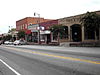 | July 24, 1989 (#89000850) | Roughly bounded by Broad St., Adair St., Church St., and Club Dr. 33°45′03″N 84°44′56″W / 33.750833°N 84.748889°W / 33.750833; -84.748889 (Douglasville Commercial Historic District) | Douglasville | |
| 6 | Pine Mountain Gold Mine |  | August 28, 2008 (#08000834) | 1881 Stockmar Rd. 33°45′29″N 84°53′01″W / 33.758083°N 84.883592°W / 33.758083; -84.883592 (Pine Mountain Gold Mine) | Villa Rica | |
| 7 | Col. William T. Roberts House |  | March 2, 1989 (#89000153) | 8652 Campbellton St. 33°44′43″N 84°44′38″W / 33.745278°N 84.743889°W / 33.745278; -84.743889 (Col. William T. Roberts House) | Douglasville | |
| 8 | Sweet Water Manufacturing Site | 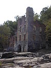 | November 23, 1977 (#77000421) | Address Restricted | Atlanta | Is in Sweetwater Creek State Park |
References
- ^ National Park Service, United States Department of the Interior, "National Register of Historic Places: Weekly List Actions", retrieved September 5, 2024.
- ^ Numbers represent an alphabetical ordering by significant words. Various colorings, defined here, differentiate National Historic Landmarks and historic districts from other NRHP buildings, structures, sites or objects.
- ^ The eight-digit number below each date is the number assigned to each location in the National Register Information System database, which can be viewed by clicking the number.
Wikimedia Commons has media related to National Register of Historic Places in Douglas County, Georgia.


