National Register of Historic Places listings in Elbert County, Georgia
This is a list of properties and districts in Elbert County, Georgia that are listed on the National Register of Historic Places (NRHP).

Map all coordinates using OpenStreetMap
Download coordinates as:
- KML
- GPX (all coordinates)
- GPX (primary coordinates)
- GPX (secondary coordinates)
This National Park Service list is complete through NPS recent listings posted September 5, 2024.[1]
- v
- t
- e
Properties on the National Register of Historic Places in Georgia by county
- Appling
- Atkinson
- Bacon
- Baker
- Baldwin
- Banks
- Barrow
- Bartow
- Ben Hill
- Berrien
- Bibb
- Bleckley
- Brantley
- Brooks
- Bryan
- Bulloch
- Burke
- Butts
- Calhoun
- Camden
- Candler
- Carroll
- Catoosa
- Charlton
- Chatham
- Chattahoochee
- Chattooga
- Cherokee
- Clarke
- Clay
- Clayton
- Clinch
- Cobb
- Coffee
- Colquitt
- Columbia
- Cook
- Coweta
- Crawford
- Crisp
- Dade
- Dawson
- Decatur
- DeKalb
- Dodge
- Dooly
- Dougherty
- Douglas
- Early
- Echols
- Effingham
- Elbert
- Emanuel
- Evans
- Fannin
- Fayette
- Floyd
- Forsyth
- Franklin
- Fulton
- Gilmer
- Glascock
- Glynn
- Gordon
- Grady
- Greene
- Gwinnett
- Habersham
- Hall
- Hancock
- Haralson
- Harris
- Hart
- Heard
- Henry
- Houston
- Irwin
- Jackson
- Jasper
- Jeff Davis
- Jefferson
- Jenkins
- Johnson
- Jones
- Lamar
- Lanier
- Laurens
- Lee
- Liberty
- Lincoln
- Long
- Lowndes
- Lumpkin
- Macon
- Madison
- Marion
- McDuffie
- McIntosh
- Meriwether
- Miller
- Mitchell
- Monroe
- Montgomery
- Morgan
- Murray
- Muscogee
- Newton
- Oconee
- Oglethorpe
- Paulding
- Peach
- Pickens
- Pierce
- Pike
- Polk
- Pulaski
- Putnam
- Quitman
- Rabun
- Randolph
- Richmond
- Rockdale
- Schley
- Screven
- Seminole
- Spalding
- Stephens
- Stewart
- Sumter
- Talbot
- Taliaferro
- Tattnall
- Taylor
- Telfair
- Terrell
- Thomas
- Tift
- Toombs
- Towns
- Treutlen
- Troup
- Turner
- Twiggs
- Union
- Upson
- Walker
- Walton
- Ware
- Warren
- Washington
- Wayne
- Webster
- Wheeler
- White
- Whitfield
- Wilcox
- Wilkes
- Wilkinson
- Worth

Current listings
| [2] | Name on the Register | Image | Date listed[3] | Location | City or town | Description |
|---|---|---|---|---|---|---|
| 1 | Alexander-Cleveland House |  | September 15, 1977 (#77000423) | 3.5 mi. NE of Ruckersville 34°11′14″N 82°44′12″W / 34.187222°N 82.736667°W / 34.187222; -82.736667 (Alexander-Cleveland House) | Ruckersville | |
| 2 | Ralph Banks Place |  | May 22, 1978 (#78000978) | N of Elberton off GA 77 34°13′37″N 82°51′39″W / 34.226944°N 82.860833°W / 34.226944; -82.860833 (Ralph Banks Place) | Elberton | |
| 3 | Bowman Commercial Historic District | Upload image | April 5, 2016 (#16000128) | Public Square on GA 17 34°12′18″N 83°01′53″W / 34.205068°N 83.031366°W / 34.205068; -83.031366 (Bowman Commercial Historic District) | Bowman | |
| 4 | Building at 6 and 7 Public Square | Upload image | September 24, 2009 (#09000750) | 6 and 7 Public Square 34°12′18″N 83°01′54″W / 34.205106°N 83.031578°W / 34.205106; -83.031578 (Building at 6 and 7 Public Square) | Bowman | |
| 5 | Asa Chandler House |  | June 22, 1982 (#82002409) | 1003 Old Petersburg Rd. 34°05′41″N 82°50′47″W / 34.09486°N 82.84627°W / 34.09486; -82.84627 (Asa Chandler House) | Elberton | |
| 6 | Dove Creek Baptist Church | Upload image | July 9, 1987 (#87001154) | GA 72 34°04′20″N 82°57′05″W / 34.072222°N 82.951389°W / 34.072222; -82.951389 (Dove Creek Baptist Church) | Elberton | demolished |
| 7 | Elbert County Courthouse |  | September 18, 1980 (#80001017) | Courthouse Sq. 34°06′36″N 82°52′08″W / 34.11°N 82.868889°W / 34.11; -82.868889 (Elbert County Courthouse) | Elberton | |
| 8 | Elberton Commercial Historic District | 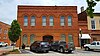 | May 20, 1982 (#82002410) | Church, Elbert, Oliver, and McIntosh Sts., and Public Sq.; also N. McIntosh, Thomas, Church, & S. Oliver Sts. 34°06′35″N 82°52′04″W / 34.109722°N 82.867778°W / 34.109722; -82.867778 (Elberton Commercial Historic District) | Elberton | Second set of addresses represents a boundary increase July 14, 2015. |
| 9 | Elberton Depot |  | September 11, 1986 (#86002399) | N. Oliver and Deadwyler Sts. 34°06′47″N 82°51′59″W / 34.113056°N 82.866389°W / 34.113056; -82.866389 (Elberton Depot) | Elberton | |
| 10 | Elberton Residential Historic District |  | August 11, 1982 (#82002411) | Roughly bounded by Elbert, Oliver, Adams, Thomas, Edwards, and Heard Sts. 34°06′22″N 82°51′55″W / 34.106111°N 82.865278°W / 34.106111; -82.865278 (Elberton Residential Historic District) | Elberton | |
| 11 | Forest Avenue Historic District |  | March 24, 2015 (#15000102) | Roughly bounded by Jones, Chestnut & W. Church Sts., Laurel & Oak Drs., Brookwood & Lake Forest Cirs., Forest & College 34°06′42″N 82°52′19″W / 34.111542°N 82.871903°W / 34.111542; -82.871903 (Forest Avenue Historic District) | Elberton | |
| 12 | Ralph Gaines House | Upload image | October 5, 1977 (#77000422) | N of Elberton on GA 368 34°12′09″N 82°48′32″W / 34.2025°N 82.808889°W / 34.2025; -82.808889 (Ralph Gaines House) | Elberton | |
| 13 | Rock Gym |  | December 31, 1998 (#98001559) | 45 Forest Ave. 34°06′39″N 82°52′19″W / 34.110833°N 82.871944°W / 34.110833; -82.871944 (Rock Gym) | Elberton | |
| 14 | Rucker House | Upload image | June 23, 1978 (#78000979) | GA 985 34°09′49″N 82°47′22″W / 34.163611°N 82.789444°W / 34.163611; -82.789444 (Rucker House) | Ruckersville |
Former listing
| [2] | Name on the Register | Image | Date listed | Date removed | Location | City or town | Description |
|---|---|---|---|---|---|---|---|
| 1 | William Allen House | Upload image | June 5, 1975 (#75000591) | September 17, 2015 | 9 mi. E of Elberton on SR 6 34°05′49″N 82°43′55″W / 34.096944°N 82.731944°W / 34.096944; -82.731944 (William Allen House) | Elberton |
References
- ^ National Park Service, United States Department of the Interior, "National Register of Historic Places: Weekly List Actions", retrieved September 5, 2024.
- ^ a b Numbers represent an alphabetical ordering by significant words. Various colorings, defined here, differentiate National Historic Landmarks and historic districts from other NRHP buildings, structures, sites or objects.
- ^ The eight-digit number below each date is the number assigned to each location in the National Register Information System database, which can be viewed by clicking the number.
Wikimedia Commons has media related to National Register of Historic Places in Elbert County, Georgia.
| |
|---|---|
| Topics | |
| Lists by state |
|
| Lists by insular areas | |
| Lists by associated state | |
| Other areas | |
| Related | |
| |


