National Register of Historic Places listings in Lowndes County, Georgia
This is a list of properties and districts in Lowndes County, Georgia that are listed on the National Register of Historic Places (NRHP).
Map all coordinates using OpenStreetMap
Download coordinates as:
- KML
- GPX (all coordinates)
- GPX (primary coordinates)
- GPX (secondary coordinates)
This National Park Service list is complete through NPS recent listings posted September 5, 2024.[1]
- v
- t
- e
Properties on the National Register of Historic Places in Georgia by county
- Appling
- Atkinson
- Bacon
- Baker
- Baldwin
- Banks
- Barrow
- Bartow
- Ben Hill
- Berrien
- Bibb
- Bleckley
- Brantley
- Brooks
- Bryan
- Bulloch
- Burke
- Butts
- Calhoun
- Camden
- Candler
- Carroll
- Catoosa
- Charlton
- Chatham
- Chattahoochee
- Chattooga
- Cherokee
- Clarke
- Clay
- Clayton
- Clinch
- Cobb
- Coffee
- Colquitt
- Columbia
- Cook
- Coweta
- Crawford
- Crisp
- Dade
- Dawson
- Decatur
- DeKalb
- Dodge
- Dooly
- Dougherty
- Douglas
- Early
- Echols
- Effingham
- Elbert
- Emanuel
- Evans
- Fannin
- Fayette
- Floyd
- Forsyth
- Franklin
- Fulton
- Gilmer
- Glascock
- Glynn
- Gordon
- Grady
- Greene
- Gwinnett
- Habersham
- Hall
- Hancock
- Haralson
- Harris
- Hart
- Heard
- Henry
- Houston
- Irwin
- Jackson
- Jasper
- Jeff Davis
- Jefferson
- Jenkins
- Johnson
- Jones
- Lamar
- Lanier
- Laurens
- Lee
- Liberty
- Lincoln
- Long
- Lowndes
- Lumpkin
- Macon
- Madison
- Marion
- McDuffie
- McIntosh
- Meriwether
- Miller
- Mitchell
- Monroe
- Montgomery
- Morgan
- Murray
- Muscogee
- Newton
- Oconee
- Oglethorpe
- Paulding
- Peach
- Pickens
- Pierce
- Pike
- Polk
- Pulaski
- Putnam
- Quitman
- Rabun
- Randolph
- Richmond
- Rockdale
- Schley
- Screven
- Seminole
- Spalding
- Stephens
- Stewart
- Sumter
- Talbot
- Taliaferro
- Tattnall
- Taylor
- Telfair
- Terrell
- Thomas
- Tift
- Toombs
- Towns
- Treutlen
- Troup
- Turner
- Twiggs
- Union
- Upson
- Walker
- Walton
- Ware
- Warren
- Washington
- Wayne
- Webster
- Wheeler
- White
- Whitfield
- Wilcox
- Wilkes
- Wilkinson
- Worth

Current listings
| [2] | Name on the Register | Image | Date listed[3] | Location | City or town | Description |
|---|---|---|---|---|---|---|
| 1 | Barber-Pittman House | 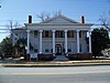 | February 12, 1980 (#80001108) | 416 N. Ashley St. 30°50′07″N 83°16′47″W / 30.835278°N 83.279722°W / 30.835278; -83.279722 (Barber-Pittman House) | Valdosta | |
| 2 | Brookwood North Historic District | 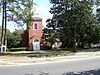 | June 2, 1995 (#95000684) | Roughly bounded by Patterson St., Georgia Ave., Oak St., Park Ave., Williams St. and Brookwood Dr. 30°51′06″N 83°17′16″W / 30.851667°N 83.287778°W / 30.851667; -83.287778 (Brookwood North Historic District) | Valdosta | Contributing property at 1521 N Patterson St. |
| 3 | Carnegie Library of Valdosta |  | January 12, 1984 (#84001120) | 305 W. Central Ave. 30°49′50″N 83°16′58″W / 30.830556°N 83.282778°W / 30.830556; -83.282778 (Carnegie Library of Valdosta) | Valdosta | Built in 1914, it now houses the Lowndes County Historical Society and Museum |
| 4 | Converse-Dalton House | 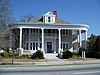 | April 28, 1983 (#83000233) | 305 N. Patterson St. 30°50′00″N 83°16′48″W / 30.8333°N 83.27988°W / 30.8333; -83.27988 (Converse-Dalton House) | Valdosta | |
| 5 | The Crescent |  | January 8, 1980 (#80001109) | 904 N. Paterson St. 30°50′22″N 83°17′02″W / 30.839444°N 83.283889°W / 30.839444; -83.283889 (The Crescent) | Valdosta | |
| 6 | Crestwood | 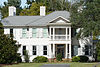 | January 12, 1984 (#84001147) | 502 Eager Rd. 30°52′14″N 83°18′10″W / 30.87047°N 83.30272°W / 30.87047; -83.30272 (Crestwood) | Valdosta | Built in 1915, it is down a private gated drive, but visible from public property. |
| 7 | Dasher High School |  | April 18, 1985 (#85000849) | 900 S. Troup St. 30°50′49″N 83°16′11″W / 30.846944°N 83.269722°W / 30.846944; -83.269722 (Dasher High School) | Valdosta | |
| 8 | East End Historic District |  | May 21, 2005 (#05000427) | NE of downtown Valdosta roughly bounded by North Ashley and E. Ann Sts., East Hill Ave., and Georgia and Florida RR 30°50′19″N 83°16′25″W / 30.838611°N 83.273611°W / 30.838611; -83.273611 (East End Historic District) | Valdosta | Contributing property at 315 E Central Ave. |
| 9 | Ewell Brown General Store | 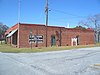 | February 21, 1997 (#97000099) | RR Ave., jct. with Lawrence St. 30°40′59″N 83°10′56″W / 30.68319°N 83.18216°W / 30.68319; -83.18216 (Ewell Brown General Store) | Lake Park | Now houses the Lake Park Museum |
| 10 | Fairview Historic District |  | June 28, 1984 (#84001149) | W. Central, Floyd, River, Varnedoe, and Wells Sts. 30°49′50″N 83°17′07″W / 30.830556°N 83.285278°W / 30.830556; -83.285278 (Fairview Historic District) | Valdosta | |
| 11 | First Presbyterian Church | 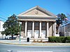 | November 2, 1987 (#87001912) | 313 N. Patterson St. 30°50′03″N 83°16′10″W / 30.834167°N 83.269444°W / 30.834167; -83.269444 (First Presbyterian Church) | Valdosta | |
| 12 | Hahira Commercial Historic District |  | March 18, 2022 (#100006746) | Centered on Main St. (GA 122) between Marshall St. and Church St. (US 41) 30°59′28″N 83°22′27″W / 30.9911°N 83.3741°W / 30.9911; -83.3741 (Hahira Commercial Historic District) | Hahira | District includes Hahira City Hall |
| 13 | Lowndes County Courthouse |  | September 18, 1980 (#80001110) | 100 E. Central Ave. 30°49′57″N 83°16′45″W / 30.8325°N 83.279167°W / 30.8325; -83.279167 (Lowndes County Courthouse) | Valdosta | |
| 14 | North Patterson Street Historic District | 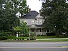 | June 28, 1984 (#84001151) | 1003-1111 N. Patterson St. 30°50′30″N 83°17′05″W / 30.841667°N 83.284722°W / 30.841667; -83.284722 (North Patterson Street Historic District) | Valdosta | |
| 15 | Southside Historic District | 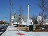 | April 27, 2007 (#07000379) | Roughly bounded by CSX tracks, Bunche Dr., Griffin Ave., Old Statenville Rd., Wisenbake Ln, Dasher Ln., and S. Patterson R 30°49′19″N 83°16′12″W / 30.822°N 83.270°W / 30.822; -83.270 (Southside Historic District) | Valdosta | |
| 16 | Sunset Hill Cemetery |  | September 10, 2004 (#04000957) | 1100 N. Oak St. 30°50′31″N 83°17′29″W / 30.841944°N 83.291389°W / 30.841944; -83.291389 (Sunset Hill Cemetery) | Valdosta | |
| 17 | Valdosta Commercial Historic District | 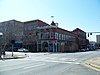 | September 15, 1983 (#83000234) | Roughly bounded by Savannah Ave., Lee, Toombs, and Valley Sts. 30°49′53″N 83°16′43″W / 30.831389°N 83.278611°W / 30.831389; -83.278611 (Valdosta Commercial Historic District) | Valdosta |
References
- ^ National Park Service, United States Department of the Interior, "National Register of Historic Places: Weekly List Actions", retrieved September 5, 2024.
- ^ Numbers represent an alphabetical ordering by significant words. Various colorings, defined here, differentiate National Historic Landmarks and historic districts from other NRHP buildings, structures, sites or objects.
- ^ The eight-digit number below each date is the number assigned to each location in the National Register Information System database, which can be viewed by clicking the number.
Wikimedia Commons has media related to National Register of Historic Places in Lowndes County, Georgia.


