National Register of Historic Places listings in Harris County, Georgia
This is a list of properties and districts in Harris County, Georgia that are listed on the National Register of Historic Places (NRHP).
Map all coordinates using OpenStreetMap
Download coordinates as:
- KML
- GPX (all coordinates)
- GPX (primary coordinates)
- GPX (secondary coordinates)
This National Park Service list is complete through NPS recent listings posted September 5, 2024.[1]
- v
- t
- e
Properties on the National Register of Historic Places in Georgia by county
- Appling
- Atkinson
- Bacon
- Baker
- Baldwin
- Banks
- Barrow
- Bartow
- Ben Hill
- Berrien
- Bibb
- Bleckley
- Brantley
- Brooks
- Bryan
- Bulloch
- Burke
- Butts
- Calhoun
- Camden
- Candler
- Carroll
- Catoosa
- Charlton
- Chatham
- Chattahoochee
- Chattooga
- Cherokee
- Clarke
- Clay
- Clayton
- Clinch
- Cobb
- Coffee
- Colquitt
- Columbia
- Cook
- Coweta
- Crawford
- Crisp
- Dade
- Dawson
- Decatur
- DeKalb
- Dodge
- Dooly
- Dougherty
- Douglas
- Early
- Echols
- Effingham
- Elbert
- Emanuel
- Evans
- Fannin
- Fayette
- Floyd
- Forsyth
- Franklin
- Fulton
- Gilmer
- Glascock
- Glynn
- Gordon
- Grady
- Greene
- Gwinnett
- Habersham
- Hall
- Hancock
- Haralson
- Harris
- Hart
- Heard
- Henry
- Houston
- Irwin
- Jackson
- Jasper
- Jeff Davis
- Jefferson
- Jenkins
- Johnson
- Jones
- Lamar
- Lanier
- Laurens
- Lee
- Liberty
- Lincoln
- Long
- Lowndes
- Lumpkin
- Macon
- Madison
- Marion
- McDuffie
- McIntosh
- Meriwether
- Miller
- Mitchell
- Monroe
- Montgomery
- Morgan
- Murray
- Muscogee
- Newton
- Oconee
- Oglethorpe
- Paulding
- Peach
- Pickens
- Pierce
- Pike
- Polk
- Pulaski
- Putnam
- Quitman
- Rabun
- Randolph
- Richmond
- Rockdale
- Schley
- Screven
- Seminole
- Spalding
- Stephens
- Stewart
- Sumter
- Talbot
- Taliaferro
- Tattnall
- Taylor
- Telfair
- Terrell
- Thomas
- Tift
- Toombs
- Towns
- Treutlen
- Troup
- Turner
- Twiggs
- Union
- Upson
- Walker
- Walton
- Ware
- Warren
- Washington
- Wayne
- Webster
- Wheeler
- White
- Whitfield
- Wilcox
- Wilkes
- Wilkinson
- Worth

Current listings
| [2] | Name on the Register | Image | Date listed[3] | Location | City or town | Description |
|---|---|---|---|---|---|---|
| 1 | Bethlehem Baptist Church Colored School |  | December 30, 2008 (#08001246) | 200 Bethlehem Dr. 32°48′19″N 84°46′55″W / 32.8053233°N 84.781905°W / 32.8053233; -84.781905 (Bethlehem Baptist Church Colored School) | Pine Mountain Valley | |
| 2 | Cason and Virginia Callaway House | Upload image | July 5, 2002 (#02000713) | 5929 State Route 116 32°45′12″N 84°55′30″W / 32.75340°N 84.92504°W / 32.75340; -84.92504 (Cason and Virginia Callaway House) | Hamilton | |
| 3 | Chipley-Pine Mountain Town Hall | 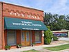 | April 17, 1986 (#86000796) | McDougal Ave. 32°51′59″N 84°51′15″W / 32.866389°N 84.854167°W / 32.866389; -84.854167 (Chipley-Pine Mountain Town Hall) | Pine Mountain | |
| 4 | William and Ann Copeland Jr. House |  | December 4, 2008 (#08000969) | 19444 State Route 116 32°47′40″N 84°44′14″W / 32.794444°N 84.737222°W / 32.794444; -84.737222 (William and Ann Copeland Jr. House) | Shiloh | |
| 5 | Welcome P. Duke Log House | 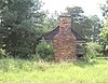 | July 23, 1999 (#99000803) | 312 Duke Rd. 32°45′12″N 84°50′53″W / 32.753333°N 84.848056°W / 32.753333; -84.848056 (Welcome P. Duke Log House) | Hamilton | The Welcome P. Duke Log House has since been dismantled. |
| 6 | Hamilton Baptist Church and Pastorium |  | August 19, 1982 (#82002448) | State Route 116 and Clay St. 32°45′26″N 84°52′35″W / 32.757222°N 84.876389°W / 32.757222; -84.876389 (Hamilton Baptist Church and Pastorium) | Hamilton | |
| 7 | Harris County Courthouse |  | September 18, 1980 (#80001089) | Courthouse Sq. 32°45′31″N 84°52′29″W / 32.758611°N 84.874722°W / 32.758611; -84.874722 (Harris County Courthouse) | Hamilton | |
| 8 | Langdale Historic District |  | November 12, 1999 (#99001299) | Vicinity of Valley, Alabama 32°48′48″N 85°10′00″W / 32.813333°N 85.166667°W / 32.813333; -85.166667 (Langdale Historic District) | Hopewell | Extends into Chambers County, Alabama |
| 9 | Mountain Hill District Consolidated School |  | December 31, 1998 (#98001558) | 47 Mountain Hill Rd., jct. with GA 219 32°41′47″N 85°01′30″W / 32.696389°N 85.025°W / 32.696389; -85.025 (Mountain Hill District Consolidated School) | Hamilton | |
| 10 | Pine Mountain State Park |  | September 25, 1997 (#97001273) | 2790 Georgia Hwy. 190 32°49′55″N 84°48′29″W / 32.831944°N 84.808056°W / 32.831944; -84.808056 (Pine Mountain State Park) | Pine Mountain | National Historic Landmark and a Georgia State Park |
| 11 | Riverview Historic District |  | November 12, 1999 (#99001300) | Vicinity of Valley, Alabama 32°47′33″N 85°08′32″W / 32.7925°N 85.142222°W / 32.7925; -85.142222 (Riverview Historic District) | Hopewell | Extends into Chambers County, Alabama |
| 12 | Story-Hadley House |  | October 22, 2002 (#02001217) | 2626 Hadley Rd. 32°49′32″N 84°58′04″W / 32.825556°N 84.967778°W / 32.825556; -84.967778 (Story-Hadley House) | Pine Mountain | Otherwise known as Sweet Home Plantation. |
| 13 | Sunnyside School-Midway Baptist Church and Midway Cemetery Historic District | 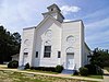 | September 9, 1999 (#99001101) | 2495 Hopewell Church Rd. at Sunnyside Church Rd. 32°49′09″N 84°59′05″W / 32.819167°N 84.984722°W / 32.819167; -84.984722 (Sunnyside School-Midway Baptist Church and Midway Cemetery Historic District) | Hamilton | |
| 14 | Thornton Plantation |  | October 29, 2004 (#04001212) | 702 Piedmont Lake Rd. and 404 Hopkins Farm Rd. 32°48′32″N 84°59′47″W / 32.808889°N 84.996389°W / 32.808889; -84.996389 (Thornton Plantation) | Pine Mountain | |
| 15 | White Hall |  | August 19, 1974 (#74000689) | Off U.S. 29 32°52′12″N 85°10′27″W / 32.87°N 85.174167°W / 32.87; -85.174167 (White Hall) | West Point | Greek Revival-style plantation home. Built in 1857. |
| 16 | Whitesville Methodist Episcopal Church, South, and Cemetery | 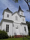 | February 22, 2002 (#02000077) | 4731 Pine Lake Rd. 32°49′11″N 85°02′07″W / 32.819722°N 85.035278°W / 32.819722; -85.035278 (Whitesville Methodist Episcopal Church, South, and Cemetery) | Whitesville |
References
- ^ National Park Service, United States Department of the Interior, "National Register of Historic Places: Weekly List Actions", retrieved September 5, 2024.
- ^ Numbers represent an alphabetical ordering by significant words. Various colorings, defined here, differentiate National Historic Landmarks and historic districts from other NRHP buildings, structures, sites or objects.
- ^ The eight-digit number below each date is the number assigned to each location in the National Register Information System database, which can be viewed by clicking the number.
Wikimedia Commons has media related to National Register of Historic Places in Harris County, Georgia.
| |
|---|---|
| Topics | |
| Lists by state |
|
| Lists by insular areas | |
| Lists by associated state | |
| Other areas | |
| Related | |
| |


