National Register of Historic Places listings in Meriwether County, Georgia

This is a list of properties and districts in Meriwether County, Georgia that are listed on the National Register of Historic Places (NRHP).
Map all coordinates using OpenStreetMap
Download coordinates as:
- KML
- GPX (all coordinates)
- GPX (primary coordinates)
- GPX (secondary coordinates)
This National Park Service list is complete through NPS recent listings posted September 5, 2024.[1]
- v
- t
- e
Properties on the National Register of Historic Places in Georgia by county
- Appling
- Atkinson
- Bacon
- Baker
- Baldwin
- Banks
- Barrow
- Bartow
- Ben Hill
- Berrien
- Bibb
- Bleckley
- Brantley
- Brooks
- Bryan
- Bulloch
- Burke
- Butts
- Calhoun
- Camden
- Candler
- Carroll
- Catoosa
- Charlton
- Chatham
- Chattahoochee
- Chattooga
- Cherokee
- Clarke
- Clay
- Clayton
- Clinch
- Cobb
- Coffee
- Colquitt
- Columbia
- Cook
- Coweta
- Crawford
- Crisp
- Dade
- Dawson
- Decatur
- DeKalb
- Dodge
- Dooly
- Dougherty
- Douglas
- Early
- Echols
- Effingham
- Elbert
- Emanuel
- Evans
- Fannin
- Fayette
- Floyd
- Forsyth
- Franklin
- Fulton
- Gilmer
- Glascock
- Glynn
- Gordon
- Grady
- Greene
- Gwinnett
- Habersham
- Hall
- Hancock
- Haralson
- Harris
- Hart
- Heard
- Henry
- Houston
- Irwin
- Jackson
- Jasper
- Jeff Davis
- Jefferson
- Jenkins
- Johnson
- Jones
- Lamar
- Lanier
- Laurens
- Lee
- Liberty
- Lincoln
- Long
- Lowndes
- Lumpkin
- Macon
- Madison
- Marion
- McDuffie
- McIntosh
- Meriwether
- Miller
- Mitchell
- Monroe
- Montgomery
- Morgan
- Murray
- Muscogee
- Newton
- Oconee
- Oglethorpe
- Paulding
- Peach
- Pickens
- Pierce
- Pike
- Polk
- Pulaski
- Putnam
- Quitman
- Rabun
- Randolph
- Richmond
- Rockdale
- Schley
- Screven
- Seminole
- Spalding
- Stephens
- Stewart
- Sumter
- Talbot
- Taliaferro
- Tattnall
- Taylor
- Telfair
- Terrell
- Thomas
- Tift
- Toombs
- Towns
- Treutlen
- Troup
- Turner
- Twiggs
- Union
- Upson
- Walker
- Walton
- Ware
- Warren
- Washington
- Wayne
- Webster
- Wheeler
- White
- Whitfield
- Wilcox
- Wilkes
- Wilkinson
- Worth

Current listings
| [2] | Name on the Register | Image | Date listed[3] | Location | City or town | Description |
|---|---|---|---|---|---|---|
| 1 | Bulloch Family House |  | January 11, 2002 (#01001429) | 5634 Spring St. 32°53′36″N 84°40′29″W / 32.893333°N 84.674722°W / 32.893333; -84.674722 (Bulloch Family House) | Warm Springs | |
| 2 | Benjamin F. Bulloch House |  | May 26, 1994 (#94000524) | 47 Bulloch St. 32°53′17″N 84°40′38″W / 32.888056°N 84.677222°W / 32.888056; -84.677222 (Benjamin F. Bulloch House) | Warm Springs | Built in the Queen Anne style in 1893 by Warm Springs' co-founder, Benjamin F. Bulloch, the house was the location of "The Bulloch House Restaurant". The house was completely destroyed by a fire on June 10, 2015.[4] |
| 3 | Carmel Rural Historic District | 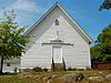 | August 10, 1998 (#97000752) | E of GA 85. Roughly bounded by Winky Branch, Gable and Sullivan Mill Rds., Flint R., and White Oak Cr. 33°10′22″N 84°32′14″W / 33.172778°N 84.537222°W / 33.172778; -84.537222 (Carmel Rural Historic District) | Alvaton | |
| 4 | Champinole |  | October 22, 1992 (#92001400) | 3920 GA Spur 109, 4 mi. NE of Greenville 33°03′15″N 84°38′50″W / 33.054167°N 84.647222°W / 33.054167; -84.647222 (Champinole) | Greenville | |
| 5 | Clarkland Farms |  | July 12, 1974 (#74000693) | La Grange Rd. 33°01′30″N 84°43′45″W / 33.025°N 84.729167°W / 33.025; -84.729167 (Clarkland Farms) | Greenville | |
| 6 | Eleanor Roosevelt School |  | May 3, 2010 (#10000019) | Parham St. at Leverette Hill Rd. 32°53′56″N 84°41′07″W / 32.898978°N 84.685169°W / 32.898978; -84.685169 (Eleanor Roosevelt School) | Warm Springs | |
| 7 | Greenville Historic District |  | March 16, 1990 (#90000433) | Bounded by Gresham, Gaston, Woodbury, Talbotton, Baldwin, Bottom, Martin, Terrell, LaGrange, and Newnan St. 33°01′34″N 84°42′51″W / 33.026111°N 84.714167°W / 33.026111; -84.714167 (Greenville Historic District) | Greenville | |
| 8 | Greenville Presbyterian Church and Cemetery |  | February 5, 2002 (#01001555) | Greenville Rocky Mount Rd, off GA41/US27 Alt. 33°03′56″N 84°42′19″W / 33.065556°N 84.705278°W / 33.065556; -84.705278 (Greenville Presbyterian Church and Cemetery) | Greenville | |
| 9 | Harman-Watson-Matthews House |  | May 9, 1973 (#73000628) | SW of Greenville on Odessadale/Durand Rd. 32°59′21″N 84°49′36″W / 32.989167°N 84.826667°W / 32.989167; -84.826667 (Harman-Watson-Matthews House) | Greenville | |
| 10 | Burwell O. Hill House |  | June 17, 1982 (#82002453) | La Grange St. 33°01′33″N 84°43′23″W / 33.025833°N 84.723056°W / 33.025833; -84.723056 (Burwell O. Hill House) | Greenville | |
| 11 | Jones-Florence Plantation | 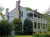 | March 29, 1984 (#84001163) | Off GA 109 33°01′24″N 84°49′04″W / 33.023333°N 84.817778°W / 33.023333; -84.817778 (Jones-Florence Plantation) | Odessadale | |
| 12 | Lone Oak Academy |  | January 28, 2002 (#01001536) | 4945 Lone Oak Rd. 33°10′19″N 84°48′51″W / 33.171944°N 84.814167°W / 33.171944; -84.814167 (Lone Oak Academy) | Lone Oak | Built c. 1870. |
| 13 | Manchester Community Building |  | January 28, 2002 (#01001537) | 105 E 2nd Ave. 32°51′07″N 84°36′54″W / 32.851944°N 84.615°W / 32.851944; -84.615 (Manchester Community Building) | Manchester | |
| 14 | Mark Hall | Upload image | May 7, 1973 (#73000629) | SW of Greenville off GA 18 32°57′27″N 84°45′00″W / 32.95752°N 84.75002°W / 32.95752; -84.75002 (Mark Hall) | Greenville | Built in 1855 |
| 15 | Meriwether County Courthouse |  | May 7, 1973 (#73000630) | Court Sq. 33°01′42″N 84°42′45″W / 33.028333°N 84.7125°W / 33.028333; -84.7125 (Meriwether County Courthouse) | Greenville | |
| 16 | Meriwether County Jail |  | May 7, 1973 (#73000631) | Reville St. and GA 27 A 33°01′46″N 84°42′42″W / 33.029444°N 84.711667°W / 33.029444; -84.711667 (Meriwether County Jail) | Greenville | |
| 17 | Oakland |  | June 28, 1982 (#82002455) | GA 41 32°55′52″N 84°41′47″W / 32.931111°N 84.696389°W / 32.931111; -84.696389 (Oakland) | Warm Springs | Built in 1829. Also known as "Oakland Plantation Inn". |
| 18 | William D. Phillips Log Cabin | Upload image | June 28, 1982 (#82002454) | GA 54 33°09′38″N 84°51′40″W / 33.160556°N 84.861111°W / 33.160556; -84.861111 (William D. Phillips Log Cabin) | Hogansville | The original structure has been destroyed. |
| 19 | Red Oak Creek Covered Bridge |  | May 7, 1973 (#73000632) | N of Woodbury on Huel Brown Rd. 33°02′18″N 84°33′12″W / 33.038333°N 84.553333°W / 33.038333; -84.553333 (Red Oak Creek Covered Bridge) | Woodbury | |
| 20 | Render Family Homestead |  | March 1, 1984 (#84001167) | GA 18 33°00′56″N 84°42′34″W / 33.015556°N 84.709444°W / 33.015556; -84.709444 (Render Family Homestead) | Greenville | |
| 21 | Twin Oaks |  | August 26, 1980 (#80001117) | 888 GA 100 33°02′16″N 84°42′54″W / 33.037778°N 84.715°W / 33.037778; -84.715 (Twin Oaks) | Greenville | |
| 22 | Warm Springs Historic District | 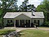 | July 30, 1974 (#74000694) | S of GA 194 and W of GA 85W 32°53′11″N 84°41′21″W / 32.886389°N 84.689167°W / 32.886389; -84.689167 (Warm Springs Historic District) | Warm Springs | US National Historic Landmark and a Georgia state historic site |
| 23 | White Oak Creek Covered Bridge |  | June 19, 1973 (#73000627) | SE of Alvaton on Covered Bridge Rd. 33°09′00″N 84°33′02″W / 33.15°N 84.550556°W / 33.15; -84.550556 (White Oak Creek Covered Bridge) | Alvaton | Bridge was built c. 1880 and destroyed by flood waters in the 1990s. The metal pilings and skeleton of the deck are all that remain. |
Former listings
| [2] | Name on the Register | Image | Date listed | Date removed | Location | City or town | Description |
|---|---|---|---|---|---|---|---|
| 1 | Hiram Warner Hill House | 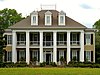 | April 7, 1983 (#83000236) | October 29, 2019 | LaGrange St. 33°01′35″N 84°43′17″W / 33.02645°N 84.72125°W / 33.02645; -84.72125 (Hiram Warner Hill House) | Greenville |
References
- ^ National Park Service, United States Department of the Interior, "National Register of Historic Places: Weekly List Actions", retrieved September 5, 2024.
- ^ a b Numbers represent an alphabetical ordering by significant words. Various colorings, defined here, differentiate National Historic Landmarks and historic districts from other NRHP buildings, structures, sites or objects.
- ^ The eight-digit number below each date is the number assigned to each location in the National Register Information System database, which can be viewed by clicking the number.
- ^ "Preservation Posts - October 2015". us1.campaign-archive1.com. Retrieved 2016-08-01.
Wikimedia Commons has media related to National Register of Historic Places in Meriwether County, Georgia.


