National Register of Historic Places listings in Early County, Georgia
This is a list of properties and districts in Early County, Georgia that are listed on the National Register of Historic Places (NRHP).
Map all coordinates using OpenStreetMap
Download coordinates as:
- KML
- GPX (all coordinates)
- GPX (primary coordinates)
- GPX (secondary coordinates)
This National Park Service list is complete through NPS recent listings posted September 5, 2024.[1]
- v
- t
- e
Properties on the National Register of Historic Places in Georgia by county
- Appling
- Atkinson
- Bacon
- Baker
- Baldwin
- Banks
- Barrow
- Bartow
- Ben Hill
- Berrien
- Bibb
- Bleckley
- Brantley
- Brooks
- Bryan
- Bulloch
- Burke
- Butts
- Calhoun
- Camden
- Candler
- Carroll
- Catoosa
- Charlton
- Chatham
- Chattahoochee
- Chattooga
- Cherokee
- Clarke
- Clay
- Clayton
- Clinch
- Cobb
- Coffee
- Colquitt
- Columbia
- Cook
- Coweta
- Crawford
- Crisp
- Dade
- Dawson
- Decatur
- DeKalb
- Dodge
- Dooly
- Dougherty
- Douglas
- Early
- Echols
- Effingham
- Elbert
- Emanuel
- Evans
- Fannin
- Fayette
- Floyd
- Forsyth
- Franklin
- Fulton
- Gilmer
- Glascock
- Glynn
- Gordon
- Grady
- Greene
- Gwinnett
- Habersham
- Hall
- Hancock
- Haralson
- Harris
- Hart
- Heard
- Henry
- Houston
- Irwin
- Jackson
- Jasper
- Jeff Davis
- Jefferson
- Jenkins
- Johnson
- Jones
- Lamar
- Lanier
- Laurens
- Lee
- Liberty
- Lincoln
- Long
- Lowndes
- Lumpkin
- Macon
- Madison
- Marion
- McDuffie
- McIntosh
- Meriwether
- Miller
- Mitchell
- Monroe
- Montgomery
- Morgan
- Murray
- Muscogee
- Newton
- Oconee
- Oglethorpe
- Paulding
- Peach
- Pickens
- Pierce
- Pike
- Polk
- Pulaski
- Putnam
- Quitman
- Rabun
- Randolph
- Richmond
- Rockdale
- Schley
- Screven
- Seminole
- Spalding
- Stephens
- Stewart
- Sumter
- Talbot
- Taliaferro
- Tattnall
- Taylor
- Telfair
- Terrell
- Thomas
- Tift
- Toombs
- Towns
- Treutlen
- Troup
- Turner
- Twiggs
- Union
- Upson
- Walker
- Walton
- Ware
- Warren
- Washington
- Wayne
- Webster
- Wheeler
- White
- Whitfield
- Wilcox
- Wilkes
- Wilkinson
- Worth

Current listings
| [2] | Name on the Register | Image | Date listed[3] | Location | City or town | Description |
|---|---|---|---|---|---|---|
| 1 | Bank of Jakin | 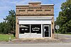 | July 25, 2003 (#03000678) | 135 S. Pearl St. 31°05′23″N 84°58′59″W / 31.08976°N 84.98303°W / 31.08976; -84.98303 (Bank of Jakin) | Jakin | Later used as city hall |
| 2 | Blakely Court Square Historic District | 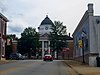 | May 9, 2002 (#02000452) | Bounded by Powell St., Smith Ave., and Church and Bay Sts. 31°22′38″N 84°56′02″W / 31.377222°N 84.933889°W / 31.377222; -84.933889 (Blakely Court Square Historic District) | Blakely | |
| 3 | James and Clara Butler House | Upload image | January 11, 2002 (#01001430) | College St. 31°22′45″N 84°56′27″W / 31.37918°N 84.94070°W / 31.37918; -84.94070 (James and Clara Butler House) | Blakely | |
| 4 | Coheelee Creek Covered Bridge |  | May 13, 1976 (#76000617) | 2 mi. N of Hilton on Old River Rd. 31°18′23″N 85°04′43″W / 31.30641°N 85.07871°W / 31.30641; -85.07871 (Coheelee Creek Covered Bridge) | Hilton | |
| 5 | Early County Courthouse |  | September 18, 1980 (#80001015) | Courthouse Sq. 31°22′39″N 84°56′03″W / 31.3775°N 84.934167°W / 31.3775; -84.934167 (Early County Courthouse) | Blakely | |
| 6 | Jane Donalson Harrell House |  | June 17, 1982 (#82002407) | SR 1975 off U.S. 84 31°05′02″N 84°59′46″W / 31.08385°N 84.99618°W / 31.08385; -84.99618 (Jane Donalson Harrell House) | Jakin | |
| 7 | Kolomoki Mounds |  | October 15, 1966 (#66000280) | 8 mi. N of Blakely on U.S. 27, Kolomoki Mounds State Park 31°28′02″N 84°56′31″W / 31.467336°N 84.941987°W / 31.467336; -84.941987 (Kolomoki Mounds) | Blakely | National Historic Landmark and a Georgia state historic site |
References
- ^ National Park Service, United States Department of the Interior, "National Register of Historic Places: Weekly List Actions", retrieved September 5, 2024.
- ^ Numbers represent an alphabetical ordering by significant words. Various colorings, defined here, differentiate National Historic Landmarks and historic districts from other NRHP buildings, structures, sites or objects.
- ^ The eight-digit number below each date is the number assigned to each location in the National Register Information System database, which can be viewed by clicking the number.
Wikimedia Commons has media related to National Register of Historic Places in Early County, Georgia.
| |
|---|---|
| Topics | |
| Lists by state |
|
| Lists by insular areas | |
| Lists by associated state | |
| Other areas | |
| Related | |
| |


