National Register of Historic Places listings in Coweta County, Georgia

This is a list of properties and districts in Coweta County, Georgia that are listed on the National Register of Historic Places (NRHP).
Map all coordinates using OpenStreetMap
Download coordinates as:
- KML
- GPX (all coordinates)
- GPX (primary coordinates)
- GPX (secondary coordinates)
This National Park Service list is complete through NPS recent listings posted September 5, 2024.[1]
- v
- t
- e
Properties on the National Register of Historic Places in Georgia by county
- Appling
- Atkinson
- Bacon
- Baker
- Baldwin
- Banks
- Barrow
- Bartow
- Ben Hill
- Berrien
- Bibb
- Bleckley
- Brantley
- Brooks
- Bryan
- Bulloch
- Burke
- Butts
- Calhoun
- Camden
- Candler
- Carroll
- Catoosa
- Charlton
- Chatham
- Chattahoochee
- Chattooga
- Cherokee
- Clarke
- Clay
- Clayton
- Clinch
- Cobb
- Coffee
- Colquitt
- Columbia
- Cook
- Coweta
- Crawford
- Crisp
- Dade
- Dawson
- Decatur
- DeKalb
- Dodge
- Dooly
- Dougherty
- Douglas
- Early
- Echols
- Effingham
- Elbert
- Emanuel
- Evans
- Fannin
- Fayette
- Floyd
- Forsyth
- Franklin
- Fulton
- Gilmer
- Glascock
- Glynn
- Gordon
- Grady
- Greene
- Gwinnett
- Habersham
- Hall
- Hancock
- Haralson
- Harris
- Hart
- Heard
- Henry
- Houston
- Irwin
- Jackson
- Jasper
- Jeff Davis
- Jefferson
- Jenkins
- Johnson
- Jones
- Lamar
- Lanier
- Laurens
- Lee
- Liberty
- Lincoln
- Long
- Lowndes
- Lumpkin
- Macon
- Madison
- Marion
- McDuffie
- McIntosh
- Meriwether
- Miller
- Mitchell
- Monroe
- Montgomery
- Morgan
- Murray
- Muscogee
- Newton
- Oconee
- Oglethorpe
- Paulding
- Peach
- Pickens
- Pierce
- Pike
- Polk
- Pulaski
- Putnam
- Quitman
- Rabun
- Randolph
- Richmond
- Rockdale
- Schley
- Screven
- Seminole
- Spalding
- Stephens
- Stewart
- Sumter
- Talbot
- Taliaferro
- Tattnall
- Taylor
- Telfair
- Terrell
- Thomas
- Tift
- Toombs
- Towns
- Treutlen
- Troup
- Turner
- Twiggs
- Union
- Upson
- Walker
- Walton
- Ware
- Warren
- Washington
- Wayne
- Webster
- Wheeler
- White
- Whitfield
- Wilcox
- Wilkes
- Wilkinson
- Worth

Current listings
| [2] | Name on the Register | Image | Date listed[3] | Location | City or town | Description |
|---|---|---|---|---|---|---|
| 1 | W. A. Brannon Store-Moreland Knitting Mills |  | December 12, 1985 (#85003332) | Main St. 33°17′07″N 84°46′11″W / 33.285278°N 84.769722°W / 33.285278; -84.769722 (W. A. Brannon Store-Moreland Knitting Mills) | Moreland | |
| 2 | Brown's Mill Battlefield | Upload image | February 29, 2024 (#100010004) | Address Restricted | Newnan vicinity | |
| 3 | Cole Town District |  | September 30, 1982 (#82002400) | Roughly bounded by Washington, Thompson, and Davis Sts., and Hooligan Alley 33°22′22″N 84°47′39″W / 33.372778°N 84.794167°W / 33.372778; -84.794167 (Cole Town District) | Newnan | |
| 4 | Coweta County Courthouse |  | September 18, 1980 (#80001006) | Courthouse Sq. 33°22′29″N 84°48′01″W / 33.374722°N 84.800278°W / 33.374722; -84.800278 (Coweta County Courthouse) | Newnan | |
| 5 | William Leonard Crowder Home Place |  | March 17, 1986 (#86000455) | 1615 Handy Rd. 33°22′38″N 84°58′07″W / 33.377222°N 84.968611°W / 33.377222; -84.968611 (William Leonard Crowder Home Place) | Newnan | |
| 6 | Goodwyn-Bailey House |  | October 29, 1992 (#92001520) | 2295 Old Poplar Rd. 33°21′16″N 84°42′19″W / 33.35431°N 84.70530°W / 33.35431; -84.70530 (Goodwyn-Bailey House) | Newnan | |
| 7 | Gordon-Banks House |  | January 20, 1972 (#72000383) | South of Newnan on U.S. 29 33°20′28″N 84°47′01″W / 33.341111°N 84.783611°W / 33.341111; -84.783611 (Gordon-Banks House) | Newnan | |
| 8 | Grantville Historic District | 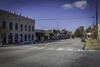 | June 14, 1991 (#91000772) | Bounded by US 29, LaGrange St., W. Grantville Rd. and the city cemetery 33°14′07″N 84°50′05″W / 33.235278°N 84.834722°W / 33.235278; -84.834722 (Grantville Historic District) | Grantville | |
| 9 | Greenville Street-LaGrange Street Historic District |  | April 28, 1983 (#83000190) | LaGrange, Nimmons, Greenville, Powell, Reese, Powell and Buchanan Sts. 33°21′57″N 84°48′02″W / 33.365833°N 84.800556°W / 33.365833; -84.800556 (Greenville Street-LaGrange Street Historic District) | Newnan | |
| 10 | Henderson-Orr House |  | June 2, 2000 (#00000562) | Junction of Thomas Powers Rd. and GA 34 33°20′15″N 84°58′51″W / 33.3375°N 84.980833°W / 33.3375; -84.980833 (Henderson-Orr House) | Stallings Crossing | |
| 11 | Hollberg Hotel |  | March 10, 1980 (#80001007) | Seavy and Barnes Sts. 33°18′04″N 84°33′11″W / 33.301111°N 84.553056°W / 33.301111; -84.553056 (Hollberg Hotel) | Senoia | |
| 12 | Newnan Commercial Historic District | 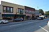 | March 20, 1990 (#90000432) | Roughly bounded by Lee, Perry, Salbide, Lagrange, W. Spring, Brown, Madison, and Jefferson 33°22′28″N 84°48′00″W / 33.374444°N 84.8°W / 33.374444; -84.8 (Newnan Commercial Historic District) | Newnan | Coweta County Courthouse is a contributing property |
| 13 | Newnan Cotton Mill and Mill Village Historic District |  | April 11, 2002 (#02000339) | Roughly bounded by E. Washington, Wilcoxen and Farmer Sts., and CSX RR. 33°22′39″N 84°47′38″W / 33.3775°N 84.793889°W / 33.3775; -84.793889 (Newnan Cotton Mill and Mill Village Historic District) | Newnan | |
| 14 | Northwest Newnan Residential Historic District |  | May 28, 1982 (#82002401) | Roughly bounded by railroad tracks, Jefferson, Cavender, Duncan, and Browns Sts. 33°22′40″N 84°48′12″W / 33.377778°N 84.803333°W / 33.377778; -84.803333 (Northwest Newnan Residential Historic District) | Newnan | |
| 15 | Oak Grove Plantation |  | May 25, 2001 (#01000535) | 4537 N US 29 33°27′32″N 84°41′26″W / 33.458889°N 84.690556°W / 33.458889; -84.690556 (Oak Grove Plantation) | Newnan | |
| 16 | Oak Hill Cemetery |  | January 27, 2012 (#11001054) | 96 Jefferson St. 33°23′09″N 84°47′52″W / 33.385855°N 84.797802°W / 33.385855; -84.797802 (Oak Hill Cemetery) | Newnan | |
| 17 | Platinum Point Historic District |  | July 12, 1990 (#90000997) | Along Jackson St., 0.5 miles (0.80 km) north of downtown Newnan 33°23′25″N 84°48′08″W / 33.390278°N 84.802222°W / 33.390278; -84.802222 (Platinum Point Historic District) | Newnan | |
| 18 | Powell Chapel School |  | June 23, 2003 (#03000535) | 620 Old Atlanta Hwy. 33°24′56″N 84°47′06″W / 33.415556°N 84.785°W / 33.415556; -84.785 (Powell Chapel School) | Newnan | |
| 19 | Mary Ray Memorial School |  | July 23, 2013 (#13000531) | 771 Raymond Sheddan Ave. 33°20′09″N 84°43′02″W / 33.3358948°N 84.7171967°W / 33.3358948; -84.7171967 (Mary Ray Memorial School) | Raymond | |
| 20 | Roscoe-Dunaway Gardens Historic District |  | December 6, 1996 (#96001414) | Roughly bounded by the Chattahoochee R., Cedar Cr., Hood Branch, and White Oak Cr. 33°29′54″N 84°50′00″W / 33.498333°N 84.833333°W / 33.498333; -84.833333 (Roscoe-Dunaway Gardens Historic District) | Roscoe | |
| 21 | Sargent Historic District |  | February 24, 2005 (#05000077) | Roughly centered on the Arnall Mill Complex at the junction of Georgia State Route 16 and Old Carrollton Rd. 33°25′52″N 84°52′03″W / 33.431111°N 84.8675°W / 33.431111; -84.8675 (Sargent Historic District) | Sargent | |
| 22 | Senoia Historic District |  | March 17, 1989 (#89000149) | Roughly bounded by Couch St., CSX Transportation tracks, Georgia State Route 16, and Pylant St. 33°18′05″N 84°33′14″W / 33.301389°N 84.553889°W / 33.301389; -84.553889 (Senoia Historic District) | Senoia | |
| 23 | George R. Sims House |  | September 27, 1990 (#90001435) | 1851 Collinsworth Rd. 33°29′31″N 84°37′08″W / 33.491944°N 84.618889°W / 33.491944; -84.618889 (George R. Sims House) | Palmetto | |
| 24 | Dr. Robert L. and Sarah Alberta Smith House |  | October 18, 1996 (#96001139) | 1262 Bob Smith Rd. 33°22′49″N 84°38′43″W / 33.380278°N 84.645278°W / 33.380278; -84.645278 (Dr. Robert L. and Sarah Alberta Smith House) | Sharpsburg | |
| 25 | Tidwell-Amis-Haynes House |  | September 11, 1997 (#97001124) | 1200 Sid Hunter Rd. 33°16′23″N 84°40′16″W / 33.273056°N 84.671111°W / 33.273056; -84.671111 (Tidwell-Amis-Haynes House) | Senoia | |
| 26 | Vinewood | 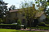 | May 11, 2011 (#11000263) | 1324 Roscoe Rd. 33°25′44″N 84°48′49″W / 33.428889°N 84.813611°W / 33.428889; -84.813611 (Vinewood) | Newnan | |
| 27 | Willcoxon-Arnold House |  | May 20, 1991 (#91000559) | One Bullsboro Dr. 33°22′55″N 84°47′35″W / 33.381944°N 84.793056°W / 33.381944; -84.793056 (Willcoxon-Arnold House) | Newnan |
References
- ^ National Park Service, United States Department of the Interior, "National Register of Historic Places: Weekly List Actions", retrieved September 5, 2024.
- ^ Numbers represent an alphabetical ordering by significant words. Various colorings, defined here, differentiate National Historic Landmarks and historic districts from other NRHP buildings, structures, sites or objects.
- ^ The eight-digit number below each date is the number assigned to each location in the National Register Information System database, which can be viewed by clicking the number.
Wikimedia Commons has media related to National Register of Historic Places in Coweta County, Georgia.


