National Register of Historic Places listings in Whitfield County, Georgia
This is a list of properties and districts in Whitfield County, Georgia, United States, that are listed on the National Register of Historic Places (NRHP).
Map all coordinates using OpenStreetMap
Download coordinates as:
- KML
- GPX (all coordinates)
- GPX (primary coordinates)
- GPX (secondary coordinates)
This National Park Service list is complete through NPS recent listings posted September 5, 2024.[1]
- v
- t
- e
Properties on the National Register of Historic Places in Georgia by county
- Appling
- Atkinson
- Bacon
- Baker
- Baldwin
- Banks
- Barrow
- Bartow
- Ben Hill
- Berrien
- Bibb
- Bleckley
- Brantley
- Brooks
- Bryan
- Bulloch
- Burke
- Butts
- Calhoun
- Camden
- Candler
- Carroll
- Catoosa
- Charlton
- Chatham
- Chattahoochee
- Chattooga
- Cherokee
- Clarke
- Clay
- Clayton
- Clinch
- Cobb
- Coffee
- Colquitt
- Columbia
- Cook
- Coweta
- Crawford
- Crisp
- Dade
- Dawson
- Decatur
- DeKalb
- Dodge
- Dooly
- Dougherty
- Douglas
- Early
- Echols
- Effingham
- Elbert
- Emanuel
- Evans
- Fannin
- Fayette
- Floyd
- Forsyth
- Franklin
- Fulton
- Gilmer
- Glascock
- Glynn
- Gordon
- Grady
- Greene
- Gwinnett
- Habersham
- Hall
- Hancock
- Haralson
- Harris
- Hart
- Heard
- Henry
- Houston
- Irwin
- Jackson
- Jasper
- Jeff Davis
- Jefferson
- Jenkins
- Johnson
- Jones
- Lamar
- Lanier
- Laurens
- Lee
- Liberty
- Lincoln
- Long
- Lowndes
- Lumpkin
- Macon
- Madison
- Marion
- McDuffie
- McIntosh
- Meriwether
- Miller
- Mitchell
- Monroe
- Montgomery
- Morgan
- Murray
- Muscogee
- Newton
- Oconee
- Oglethorpe
- Paulding
- Peach
- Pickens
- Pierce
- Pike
- Polk
- Pulaski
- Putnam
- Quitman
- Rabun
- Randolph
- Richmond
- Rockdale
- Schley
- Screven
- Seminole
- Spalding
- Stephens
- Stewart
- Sumter
- Talbot
- Taliaferro
- Tattnall
- Taylor
- Telfair
- Terrell
- Thomas
- Tift
- Toombs
- Towns
- Treutlen
- Troup
- Turner
- Twiggs
- Union
- Upson
- Walker
- Walton
- Ware
- Warren
- Washington
- Wayne
- Webster
- Wheeler
- White
- Whitfield
- Wilcox
- Wilkes
- Wilkinson
- Worth

Current listings
| [2] | Name on the Register | Image | Date listed[3] | Location | City or town | Description |
|---|---|---|---|---|---|---|
| 1 | Thomas A. Berry House |  | April 5, 1984 (#84001303) | 506 Hawthorne St. 34°46′33″N 84°57′47″W / 34.775833°N 84.963056°W / 34.775833; -84.963056 (Thomas A. Berry House) | Dalton | |
| 2 | Ainsworth E. Blunt House |  | July 9, 1980 (#80004460) | 506 S. Thornton Ave. 34°46′00″N 84°58′19″W / 34.766667°N 84.971944°W / 34.766667; -84.971944 (Ainsworth E. Blunt House) | Dalton | |
| 3 | Crown Mill Historic District |  | May 30, 1979 (#79000751) | U.S. 41 34°47′03″N 84°58′22″W / 34.784167°N 84.972778°W / 34.784167; -84.972778 (Crown Mill Historic District) | Dalton | |
| 4 | Dalton Commercial Historic District |  | December 5, 1988 (#88001831) | Roughly bounded by Hamilton, Pentz, Waugh and Morris Sts.; also roughly centered on Hamilton St., and bounded by S. Thornton Ave., Morris and Hawthorne Sts., and the railroad lines 34°46′16″N 84°58′05″W / 34.771111°N 84.968056°W / 34.771111; -84.968056 (Dalton Commercial Historic District) | Dalton | Second set of boundaries represents a boundary increase of April 19, 2006 |
| 5 | William C. Martin House |  | July 15, 1982 (#82002497) | 101 S. Selvidge St. 34°46′16″N 84°58′15″W / 34.771111°N 84.970833°W / 34.771111; -84.970833 (William C. Martin House) | Dalton | |
| 6 | Masonic Lodge No. 238 |  | February 22, 1996 (#96000127) | 600 S. Hamilton St. 34°45′57″N 84°58′05″W / 34.765833°N 84.968056°W / 34.765833; -84.968056 (Masonic Lodge No. 238) | Dalton | |
| 7 | McCarty Subdivision Historic District |  | July 5, 2002 (#02000714) | Thornton Place, Willow Park Dr., Sunset Cirtcle, and Walnut Ave. 34°45′35″N 84°58′20″W / 34.759722°N 84.972222°W / 34.759722; -84.972222 (McCarty Subdivision Historic District) | Dalton | |
| 8 | Prater's Mill |  | April 25, 1978 (#78001010) | N of Dalton on GA 2 34°53′45″N 84°55′20″W / 34.895833°N 84.922222°W / 34.895833; -84.922222 (Prater's Mill) | Dalton | |
| 9 | A. D. Strickland Store |  | May 10, 2005 (#05000405) | 1385 Dawnville Rd. 34°49′17″N 84°52′45″W / 34.82151°N 84.87908°W / 34.82151; -84.87908 (A. D. Strickland Store) | Dalton | |
| 10 | Thornton Avenue-Murray Hill Historic District |  | June 4, 1992 (#92000669) | Roughly bounded by Crawford St., Thornton Ave., W. Franklin St., Valley Dr., Emory St. and West Hill Cemetery 34°46′04″N 84°58′28″W / 34.767778°N 84.974444°W / 34.767778; -84.974444 (Thornton Avenue-Murray Hill Historic District) | Dalton | |
| 11 | Western and Atlantic Depot | 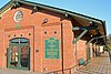 | April 6, 1978 (#78001009) | Depot St., W end of King St. 34°46′20″N 84°58′02″W / 34.77236°N 84.96712°W / 34.77236; -84.96712 (Western and Atlantic Depot) | Dalton | Built in 1914, renovated in 2009. Also a contributing property to the Dalton Commercial Historic District and is now a visitor's center. |
| 12 | Western and Atlantic Railroad Tunnel at Tunnel Hill |  | January 11, 2002 (#01001431) | Western and Atlantic Railroad 34°50′19″N 85°01′52″W / 34.838611°N 85.031111°W / 34.838611; -85.031111 (Western and Atlantic Railroad Tunnel at Tunnel Hill) | Tunnel Hill |
References
- ^ National Park Service, United States Department of the Interior, "National Register of Historic Places: Weekly List Actions", retrieved September 5, 2024.
- ^ Numbers represent an alphabetical ordering by significant words. Various colorings, defined here, differentiate National Historic Landmarks and historic districts from other NRHP buildings, structures, sites or objects.
- ^ The eight-digit number below each date is the number assigned to each location in the National Register Information System database, which can be viewed by clicking the number.
Wikimedia Commons has media related to National Register of Historic Places in Whitfield County, Georgia.


