National Register of Historic Places listings in Stewart County, Georgia
This is a list of properties and districts in Stewart County, Georgia that are listed on the National Register of Historic Places (NRHP).
Map all coordinates using OpenStreetMap
Download coordinates as:
- KML
- GPX (all coordinates)
- GPX (primary coordinates)
- GPX (secondary coordinates)
This National Park Service list is complete through NPS recent listings posted September 5, 2024.[1]
- v
- t
- e
Properties on the National Register of Historic Places in Georgia by county
- Appling
- Atkinson
- Bacon
- Baker
- Baldwin
- Banks
- Barrow
- Bartow
- Ben Hill
- Berrien
- Bibb
- Bleckley
- Brantley
- Brooks
- Bryan
- Bulloch
- Burke
- Butts
- Calhoun
- Camden
- Candler
- Carroll
- Catoosa
- Charlton
- Chatham
- Chattahoochee
- Chattooga
- Cherokee
- Clarke
- Clay
- Clayton
- Clinch
- Cobb
- Coffee
- Colquitt
- Columbia
- Cook
- Coweta
- Crawford
- Crisp
- Dade
- Dawson
- Decatur
- DeKalb
- Dodge
- Dooly
- Dougherty
- Douglas
- Early
- Echols
- Effingham
- Elbert
- Emanuel
- Evans
- Fannin
- Fayette
- Floyd
- Forsyth
- Franklin
- Fulton
- Gilmer
- Glascock
- Glynn
- Gordon
- Grady
- Greene
- Gwinnett
- Habersham
- Hall
- Hancock
- Haralson
- Harris
- Hart
- Heard
- Henry
- Houston
- Irwin
- Jackson
- Jasper
- Jeff Davis
- Jefferson
- Jenkins
- Johnson
- Jones
- Lamar
- Lanier
- Laurens
- Lee
- Liberty
- Lincoln
- Long
- Lowndes
- Lumpkin
- Macon
- Madison
- Marion
- McDuffie
- McIntosh
- Meriwether
- Miller
- Mitchell
- Monroe
- Montgomery
- Morgan
- Murray
- Muscogee
- Newton
- Oconee
- Oglethorpe
- Paulding
- Peach
- Pickens
- Pierce
- Pike
- Polk
- Pulaski
- Putnam
- Quitman
- Rabun
- Randolph
- Richmond
- Rockdale
- Schley
- Screven
- Seminole
- Spalding
- Stephens
- Stewart
- Sumter
- Talbot
- Taliaferro
- Tattnall
- Taylor
- Telfair
- Terrell
- Thomas
- Tift
- Toombs
- Towns
- Treutlen
- Troup
- Turner
- Twiggs
- Union
- Upson
- Walker
- Walton
- Ware
- Warren
- Washington
- Wayne
- Webster
- Wheeler
- White
- Whitfield
- Wilcox
- Wilkes
- Wilkinson
- Worth

Current listings
| [2] | Name on the Register | Image | Date listed[3] | Location | City or town | Description |
|---|---|---|---|---|---|---|
| 1 | Armstrong House |  | June 29, 1982 (#82002466) | Broad St. 32°03′04″N 84°47′34″W / 32.051111°N 84.792778°W / 32.051111; -84.792778 (Armstrong House) | Lumpkin | |
| 2 | Bedingfield Inn |  | May 7, 1973 (#73000643) | Cotton St. 32°03′02″N 84°47′44″W / 32.050556°N 84.795556°W / 32.050556; -84.795556 (Bedingfield Inn) | Lumpkin | Built c. 1836 |
| 3 | Bush-Usher House | Upload image | June 29, 1982 (#82002467) | E. Main St. 32°02′58″N 84°47′29″W / 32.049444°N 84.791389°W / 32.049444; -84.791389 (Bush-Usher House) | Lumpkin | |
| 4 | Dr. Miller's Office | Upload image | June 29, 1982 (#82002468) | E. Main St. 32°03′00″N 84°47′31″W / 32.05°N 84.791944°W / 32.05; -84.791944 (Dr. Miller's Office) | Lumpkin | |
| 5 | East Main Street Residential Historic District | Upload image | June 29, 1982 (#82002469) | E. Main St. 32°02′59″N 84°47′34″W / 32.049722°N 84.792778°W / 32.049722; -84.792778 (East Main Street Residential Historic District) | Lumpkin | |
| 6 | Green Grove Church, School, and Cemetery | 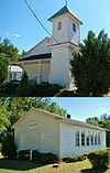 | June 20, 1995 (#95000734) | 4062 Old Lumpkin-Eufaula Rd. 32°00′26″N 84°51′44″W / 32.007222°N 84.862222°W / 32.007222; -84.862222 (Green Grove Church, School, and Cemetery) | Lumpkin | |
| 7 | Dr. R. L. Grier House | Upload image | June 29, 1982 (#82002470) | Broad St. 32°03′04″N 84°48′10″W / 32.051111°N 84.802778°W / 32.051111; -84.802778 (Dr. R. L. Grier House) | Lumpkin | |
| 8 | George Y. Harrell House | Upload image | June 29, 1982 (#82002471) | Broad St. 32°03′02″N 84°48′09″W / 32.050556°N 84.8025°W / 32.050556; -84.8025 (George Y. Harrell House) | Lumpkin | |
| 9 | Jared Irwin House | Upload image | June 29, 1982 (#82002472) | E. Main St. 32°02′58″N 84°47′31″W / 32.049444°N 84.791944°W / 32.049444; -84.791944 (Jared Irwin House) | Lumpkin | |
| 10 | Louvale Church Row Historic District |  | April 11, 1986 (#86000747) | US 27 32°10′38″N 84°49′31″W / 32.177222°N 84.825278°W / 32.177222; -84.825278 (Louvale Church Row Historic District) | Louvale | |
| 11 | Lumpkin Commercial Historic District |  | June 29, 1982 (#82002473) | Main, Broad, Cotton, and Mulberry Sts. 32°03′00″N 84°47′41″W / 32.05°N 84.794722°W / 32.05; -84.794722 (Lumpkin Commercial Historic District) | Lumpkin | |
| 12 | Mathis House | Upload image | June 29, 1982 (#82002474) | E. Main St. 32°03′00″N 84°47′28″W / 32.05°N 84.791111°W / 32.05; -84.791111 (Mathis House) | Lumpkin | |
| 13 | Dr. Thomas B. Miller House |  | March 2, 1988 (#87001900) | 97 Nicholson St. 32°05′17″N 84°40′06″W / 32.088056°N 84.668333°W / 32.088056; -84.668333 (Dr. Thomas B. Miller House) | Richland | |
| 14 | Old Chattahoochee County Courthouse |  | September 18, 1980 (#80001233) | 3557 South Lumpkin Road 32°23′02″N 84°57′31″W / 32.3839°N 84.9585°W / 32.3839; -84.9585 (Old Chattahoochee County Courthouse) | Columbus | One of three antebellum courthouses still existing in Georgia. Currently part of the Historic Westville museum in Columbus. |
| 15 | Pigtail Alley Historic District | Upload image | June 29, 1982 (#82002475) | Old Chestnut Rd. 32°02′49″N 84°48′01″W / 32.046944°N 84.800278°W / 32.046944; -84.800278 (Pigtail Alley Historic District) | Lumpkin | |
| 16 | Nathaniel Prothro Plantation |  | May 2, 1985 (#85000939) | Old Americus Rd. 32°06′05″N 84°39′02″W / 32.101389°N 84.650556°W / 32.101389; -84.650556 (Nathaniel Prothro Plantation) | Richland | |
| 17 | Richland Historic District |  | May 5, 1986 (#86001021) | Roughly bounded by Ponder, Harmony, Broad and Olemen, and Wali Sts. 32°05′27″N 84°39′45″W / 32.090833°N 84.6625°W / 32.090833; -84.6625 (Richland Historic District) | Richland | |
| 18 | Stoddard Rockwell House | Upload image | June 29, 1982 (#82002476) | Rockwell St. 32°03′07″N 84°47′44″W / 32.051944°N 84.795556°W / 32.051944; -84.795556 (Stoddard Rockwell House) | Lumpkin | |
| 19 | Roods Landing site |  | August 19, 1975 (#75000609) | S of Omaha at confluence of Rood Creek and the Chattahoochee River 32°01′40″N 85°02′37″W / 32.027778°N 85.043611°W / 32.027778; -85.043611 (Roods Landing site) | Omaha | |
| 20 | Second Methodist Church | Upload image | June 29, 1982 (#82002477) | Mulberry St. 32°02′49″N 84°47′37″W / 32.046944°N 84.793611°W / 32.046944; -84.793611 (Second Methodist Church) | Lumpkin | |
| 21 | Singer-Moye Archeological Site | Upload image | August 1, 1975 (#75000608) | Address Restricted | Lumpkin | |
| 22 | Smith-Alston House | Upload image | June 20, 1980 (#80001235) | 405 Ponder St. 32°05′38″N 84°39′42″W / 32.093889°N 84.661667°W / 32.093889; -84.661667 (Smith-Alston House) | Richland | |
| 23 | Stewart County Courthouse |  | September 18, 1980 (#80001234) | Courthouse Sq. 32°03′01″N 84°47′40″W / 32.050278°N 84.794444°W / 32.050278; -84.794444 (Stewart County Courthouse) | Lumpkin | |
| 24 | John A. Tucker House | Upload image | June 29, 1982 (#82002478) | Florence St. 32°03′10″N 84°47′47″W / 32.052778°N 84.796389°W / 32.052778; -84.796389 (John A. Tucker House) | Lumpkin | |
| 25 | Uptown Residential Historic District |  | June 29, 1982 (#82002479) | Broad and Main Sts. 32°03′06″N 84°47′52″W / 32.051667°N 84.797778°W / 32.051667; -84.797778 (Uptown Residential Historic District) | Lumpkin | |
| 26 | Usher House |  | June 29, 1982 (#82002480) | Florence St. 32°03′08″N 84°48′04″W / 32.052222°N 84.801111°W / 32.052222; -84.801111 (Usher House) | Lumpkin | Built c. 1836 |
| 27 | West Hill |  | September 18, 1978 (#78001006) | S of Lumpkin on U.S. 27 32°00′20″N 84°47′53″W / 32.005556°N 84.798056°W / 32.005556; -84.798056 (West Hill) | Lumpkin |
References
- ^ National Park Service, United States Department of the Interior, "National Register of Historic Places: Weekly List Actions", retrieved September 5, 2024.
- ^ Numbers represent an alphabetical ordering by significant words. Various colorings, defined here, differentiate National Historic Landmarks and historic districts from other NRHP buildings, structures, sites or objects.
- ^ The eight-digit number below each date is the number assigned to each location in the National Register Information System database, which can be viewed by clicking the number.
Wikimedia Commons has media related to National Register of Historic Places in Stewart County, Georgia.


