National Register of Historic Places listings in Washington County, Georgia

This is a list of properties and districts in Washington County, Georgia that are listed on the National Register of Historic Places (NRHP).
Map all coordinates using OpenStreetMap
Download coordinates as:
- KML
- GPX (all coordinates)
- GPX (primary coordinates)
- GPX (secondary coordinates)
This National Park Service list is complete through NPS recent listings posted September 5, 2024.[1]
- v
- t
- e
Properties on the National Register of Historic Places in Georgia by county
- Appling
- Atkinson
- Bacon
- Baker
- Baldwin
- Banks
- Barrow
- Bartow
- Ben Hill
- Berrien
- Bibb
- Bleckley
- Brantley
- Brooks
- Bryan
- Bulloch
- Burke
- Butts
- Calhoun
- Camden
- Candler
- Carroll
- Catoosa
- Charlton
- Chatham
- Chattahoochee
- Chattooga
- Cherokee
- Clarke
- Clay
- Clayton
- Clinch
- Cobb
- Coffee
- Colquitt
- Columbia
- Cook
- Coweta
- Crawford
- Crisp
- Dade
- Dawson
- Decatur
- DeKalb
- Dodge
- Dooly
- Dougherty
- Douglas
- Early
- Echols
- Effingham
- Elbert
- Emanuel
- Evans
- Fannin
- Fayette
- Floyd
- Forsyth
- Franklin
- Fulton
- Gilmer
- Glascock
- Glynn
- Gordon
- Grady
- Greene
- Gwinnett
- Habersham
- Hall
- Hancock
- Haralson
- Harris
- Hart
- Heard
- Henry
- Houston
- Irwin
- Jackson
- Jasper
- Jeff Davis
- Jefferson
- Jenkins
- Johnson
- Jones
- Lamar
- Lanier
- Laurens
- Lee
- Liberty
- Lincoln
- Long
- Lowndes
- Lumpkin
- Macon
- Madison
- Marion
- McDuffie
- McIntosh
- Meriwether
- Miller
- Mitchell
- Monroe
- Montgomery
- Morgan
- Murray
- Muscogee
- Newton
- Oconee
- Oglethorpe
- Paulding
- Peach
- Pickens
- Pierce
- Pike
- Polk
- Pulaski
- Putnam
- Quitman
- Rabun
- Randolph
- Richmond
- Rockdale
- Schley
- Screven
- Seminole
- Spalding
- Stephens
- Stewart
- Sumter
- Talbot
- Taliaferro
- Tattnall
- Taylor
- Telfair
- Terrell
- Thomas
- Tift
- Toombs
- Towns
- Treutlen
- Troup
- Turner
- Twiggs
- Union
- Upson
- Walker
- Walton
- Ware
- Warren
- Washington
- Wayne
- Webster
- Wheeler
- White
- Whitfield
- Wilcox
- Wilkes
- Wilkinson
- Worth

Current listings
| [2] | Name on the Register | Image | Date listed[3] | Location | City or town | Description |
|---|---|---|---|---|---|---|
| 1 | Church-Smith-Harris Street Historic District | Upload image | December 31, 1987 (#87001268) | E. Church, S. Smith, and S. Harris Sts. 32°58′44″N 82°48′29″W / 32.978889°N 82.808056°W / 32.978889; -82.808056 (Church-Smith-Harris Street Historic District) | Sandersville | |
| 2 | City Cemetery | 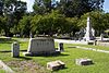 | August 3, 1987 (#87001296) | W. Church, Cemetery, and Haynes Sts. 32°58′57″N 82°48′55″W / 32.9825°N 82.815278°W / 32.9825; -82.815278 (City Cemetery) | Sandersville | |
| 3 | Thomas Jefferson Elder High and Industrial School |  | May 12, 1981 (#81000202) | 316 Hall St. 32°58′38″N 82°48′58″W / 32.97730°N 82.81605°W / 32.97730; -82.81605 (Thomas Jefferson Elder High and Industrial School) | Sandersville | |
| 4 | Forest Grove | Upload image | January 26, 2005 (#04001556) | 1200 GA 242/Riddleville Rd. 32°57′51″N 82°47′25″W / 32.96416°N 82.79021°W / 32.96416; -82.79021 (Forest Grove) | Sandersville | library web page |
| 5 | Francis Plantation | Upload image | July 3, 1975 (#75000616) | SE of Davisboro on SR 2189 (Josey Church Road?) 32°55′52″N 82°33′28″W / 32.931111°N 82.557778°W / 32.931111; -82.557778 (Francis Plantation) | Davisboro | |
| 6 | Holt Brothers Banking Company Building |  | July 28, 1994 (#94000710) | 100-106 Malone St. 32°59′02″N 82°48′39″W / 32.98385°N 82.81092°W / 32.98385; -82.81092 (Holt Brothers Banking Company Building) | Sandersville | |
| 7 | James E. Johnson House |  | July 28, 1994 (#94000711) | 425 W. Church St. 32°58′54″N 82°49′03″W / 32.98155°N 82.81745°W / 32.98155; -82.81745 (James E. Johnson House) | Sandersville | |
| 8 | James Kelley House | Upload image | July 28, 1994 (#94000712) | Tennille-Harrison Rd. E of jct. with GA 15 32°55′53″N 82°48′01″W / 32.93130°N 82.80018°W / 32.93130; -82.80018 (James Kelley House) | Tennille | |
| 9 | Charles Madden House |  | July 28, 1994 (#94000713) | 302 E. South Central St. 32°56′12″N 82°48′28″W / 32.93677°N 82.80790°W / 32.93677; -82.80790 (Charles Madden House) | Tennille | |
| 10 | North Harris Street Historic District | Upload image | July 20, 1989 (#89000801) | Roughly bounded by First Ave., Washington Ave., E. McCarty St., N. Harris St., Malone St., and Warthen St. 32°59′20″N 82°48′37″W / 32.988889°N 82.810278°W / 32.988889; -82.810278 (North Harris Street Historic District) | Sandersville | |
| 11 | Sandersville Commercial and Industrial District |  | March 1, 2002 (#02000120) | Roughly Jernigan, Gilmore, North Smith, East Haynes, W. Haynes, and Warthen Sts. 32°59′03″N 82°48′35″W / 32.984167°N 82.809722°W / 32.984167; -82.809722 (Sandersville Commercial and Industrial District) | Sandersville | |
| 12 | Sandersville High School | Upload image | December 9, 2019 (#100004745) | 514 North Harris St. 32°59′41″N 82°48′33″W / 32.9946°N 82.8091°W / 32.9946; -82.8091 (Sandersville High School) | Sandersville | |
| 13 | Thomas W. Smith House |  | July 28, 1994 (#94000714) | 306 N. Main St. 32°56′21″N 82°48′38″W / 32.939141°N 82.81049°W / 32.939141; -82.81049 (Thomas W. Smith House) | Tennille | |
| 14 | Tennille Banking Company Building |  | July 28, 1994 (#94000715) | 102-104 N. Main St. 32°56′11″N 82°48′41″W / 32.936389°N 82.811389°W / 32.936389; -82.811389 (Tennille Banking Company Building) | Tennille | |
| 15 | Tennille Baptist Church | 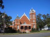 | July 28, 1994 (#94000716) | 201-205 N. Main St. 32°56′20″N 82°48′41″W / 32.93876°N 82.81137°W / 32.93876; -82.81137 (Tennille Baptist Church) | Tennille | |
| 16 | Tennille Woman's Clubhouse | 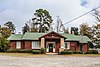 | July 1, 1998 (#98000815) | 132 Smith St. 32°56′16″N 82°48′45″W / 32.93777°N 82.81259°W / 32.93777; -82.81259 (Tennille Woman's Clubhouse) | Tennille | |
| 17 | Warthen Historic District | 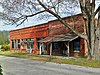 | July 25, 1997 (#97000755) | Jct. of GA 15, GA 102, Warthen St., Old Sadersville-Sparta and Walker Dairy Rds. 33°06′12″N 82°48′18″W / 33.103333°N 82.805°W / 33.103333; -82.805 (Warthen Historic District) | Warthen | |
| 18 | Washington County Courthouse |  | September 18, 1980 (#80001260) | Courthouse Sq. 32°59′00″N 82°48′43″W / 32.983333°N 82.811944°W / 32.983333; -82.811944 (Washington County Courthouse) | Sandersville | Is also in the Sandersville Commercial and Industrial District |
| 19 | Washington Manufacturing Company | Upload image | July 28, 1994 (#94000717) | Between E. Montgomery and Church Sts. at White Line St. 32°56′33″N 82°48′16″W / 32.94241°N 82.80443°W / 32.94241; -82.80443 (Washington Manufacturing Company) | Tennille | Main building has been demolished |
| 20 | Wrightsville and Tennille Railroad Company Building | 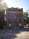 | July 28, 1994 (#94000718) | 119 Central Ave. 32°56′06″N 82°48′46″W / 32.93500°N 82.81276°W / 32.93500; -82.81276 (Wrightsville and Tennille Railroad Company Building) | Tennille |
References
Wikimedia Commons has media related to National Register of Historic Places in Washington County, Georgia.
- ^ National Park Service, United States Department of the Interior, "National Register of Historic Places: Weekly List Actions", retrieved September 5, 2024.
- ^ Numbers represent an alphabetical ordering by significant words. Various colorings, defined here, differentiate National Historic Landmarks and historic districts from other NRHP buildings, structures, sites or objects.
- ^ The eight-digit number below each date is the number assigned to each location in the National Register Information System database, which can be viewed by clicking the number.


